(Courtesy Department of Special Collections, McFarlin Library, University of Tulsa).
The Investigation of Potential Mass Grave Locations for the Tulsa Race Riot
by Robert L. Brooks and Alan H. Witten
Introduction
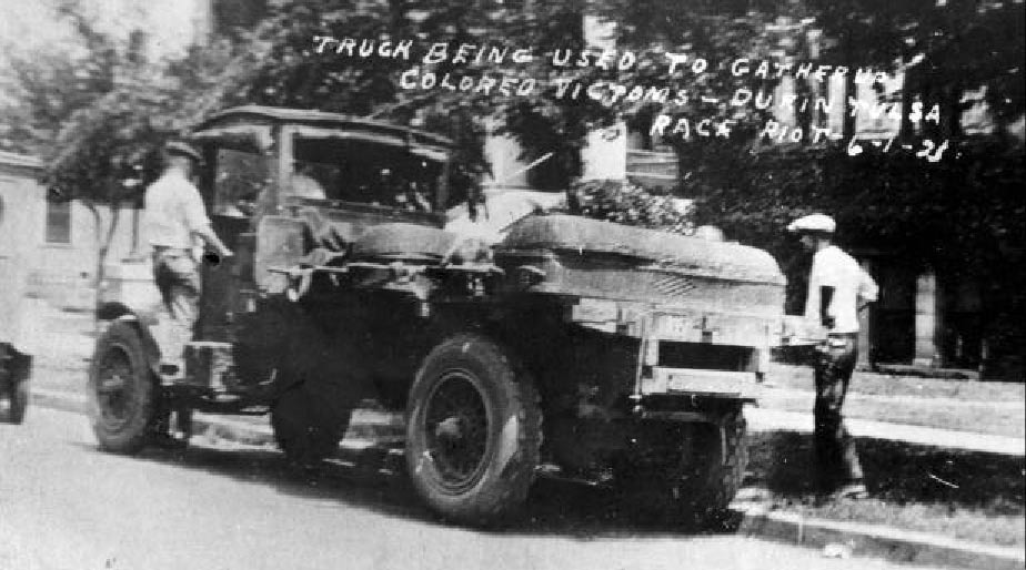
On the night of May 31 and June 1, 1921 the City of Tulsa witnessed a racial conflict between whites and the minority black population living in the Greenwood section that was unprecedented in United States history during the twentieth century. This violence, somewhat erroneously labeled as a riot, was brought about by the inflammatory coverage by the Tulsa Tribune of an alleged rape attempt of a white girl by a young black male. Tensions had been mounting with a number of racial incidents occurring prior to the night of May 31. The economic success of the Greenwood community undoubtedly played a role in fueling resentment among the white population and further escalating the violence. Through the night of May 31, and into the morning of June 1, whites virtually destroyed the Greenwood section. There were an undetermined number of deaths, both black and white, with estimates ranging from the official count of 36 to approximately 300. Over 1,000 residences were burned and another 400 looted. The business district of Greenwood was totally destroyed and probably accounts for much of the $4 million in claims filed against the city in 1921.1 Following this night of destruction and bloodshed, blacks were forcibly interned under armed guard. Eventually, over 4,000 blacks were held at the fairgrounds and other locations. Under provisions of the imposed martial law, blacks also were required to carry identity or "green cards."
This introduction only serves to broadly portray the conditions that existed in Tulsa during the "Race Riot." Detailed accounting regarding the causes of the riot, the progression of events, casualties, and property are discussed in other chapters of this report. This study focuses on those who died during the violence, what happened to their remains, and our efforts to relocate them almost 80 years later.
Casualties in the Tulsa Race Riot
As portrayed in the many studies concerning the Tulsa Race Riot, there is no well- documented evidence for the number of people who died during the violence. Ellsworth notes that the Department of Health's Bureau of Vital Statistics estimate was ten whites and 26 blacks, whereas estimates in the Red Cross records were around 300 deaths.2 There were other figures in the Tulsa Tribune, in two contradictory articles, of casualties of 68 and/or 175. While an accurate number of individuals who died during the violence may not be possible some 80 years later, some perspective can be gained by examining the black population of Tulsa and the Greenwood section and likely mortality profiles during a conflict of this nature.
It is estimated that approximately 11,000 blacks resided in Tulsa in 1921, most living in the area of the Greenwood section. The black population probably represented around ten percent of the total population of Tulsa. Using the Bureau of Vital Statistics counts, casualties among blacks using this statistic would be two percent of the black population.
Given the intensity of the conflict and the fact that many of the blacks resisting invasion of their community by whites were armed veterans of World War I, it would not be unreasonable to estimate 150 to 300 deaths. A death toll of 150 is only slightly greater than one percent of the black population. It is also suspected that the number of whites who died would exceed the ten individuals cited by the Department of Health. Unlike many riots, the racial conflict in Tulsa on the night of May 31, initially contained well-armed groups of blacks and whites. Later, as blacks were overrun by the increasing number of whites invading Greenwood, they lost the numerical capability for defending their property and sometimes, their lives.
The historicity of the Tulsa Race Riot must also be factored into the intensity of the violence. World War I ended three years prior to the violence. Thus, there were many blacks as well as white males who retained recent knowledge of warfare and armed conflict. Some of these veterans probably had retained their rifles from the war. Simply stated, this was not a riot of a few individuals with shotguns and pistols pitted against unarmed victims, at least not at the beginning.
Based on these considerations, the mortality profile would have comparable numbers of deaths among black and white males initially. As white numbers swelled and they successfully made their way into Greenwood, the number of black deaths would increase and also would reflect increasing numbers of women and children in residences. This profiling provides some credibility (although no hard evidence), for casualty counts between 175 and 300. If there were a greater number of victims than reported, then the City of Tulsa and the Army National Guard would have to deal with a significant health problem. Based on weather records for the City of Tulsa on May 31 and June 1, the temperatures hovered around 100 degrees. This would have made it a necessity that victims be handled expediently to prevent outbreaks of disease. One means of dealing with the deaths of large numbers of people is through mass graves. The following section discusses the plausibility of mass graves and possible locations.
Mass Graves and the Tulsa Race Riot
There are numerous accounts as to the disposition of the riot victims. There are reports of victims being placed on flatbed railroad cars and moved by rail from Tulsa. Other accounts have victims being thrown in the Arkansas River or being incinerated. However, the most frequently reported version is of victims being buried in mass graves. Some of these are oral histories of riot survivors. However, in many other cases they are secondary histories, stories that have been handed down through generations and across kinship lines as well. The difficulty here has been distinguishing oral histories that carry a higher level of credibility where there is some additional thread of evidence, information, or something that makes that particular individual's testimony more believable, from others of more speculative nature. In sorting through the hundreds of taped oral histories, telephone calls, and written accounts, three locations were identified that held greater credibility. This was based on the frequency of their reporting, the veracity of the individuals giving the account, and the plausibility of the location. What is meant by plausibility is whether the location would have functioned as a mass grave or as a means of disposing of the victims. For example, the city incinerator was reportedly used to cremate riot victims. However, according to Clyde Snow, an internationally known forensic scientist, this would not have been a feasible strategy based on what we know of the size of the incinerator and the likely number of riot victims. It would have been too time consuming and requiring too much engineering coordination. The three locations frequently cited and thought to merit further study were Newblock Park, Oaklawn Cemetery, and Booker T. Washington Cemetery.
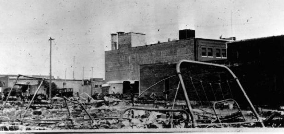
Bed frames rise out of the destruction in the Greenwood district (Courtesy Oklahoma Historical Society).
Newblock Park is located adjacent to the downtown area and the Greenwood section. It is bounded to the south by the Arkansas River, to the east by a residential area and 7th Street, to the north by Charles Page Boulevard, and on the west by more city property (Figure 1). At the time of the Tulsa Race Riot, Newblock Park was the location of the city landfill, the city incinerator, and a substantial amount of open land. Because of wooded tree lines, much of the area of Newblock may have been blocked from view. Today, Newblock Park is dramatically altered from the way it appeared in 1921; much of the park is greenspace. However, this greenspace hides the remains of old water pumping system buildings, numerous utility lines, as well as the Parkview drainage channel leading to the Arkansas River. There is also a railroad line between the park and the Arkansas River as well as a levee constructed by the Corps of Engineers in the 1940s. Thus, the landscape is markedly different than that witnessed by Tulsans in the summer of 1921. There have been numerous unverified accounts of victims of the riot being buried in Newblock by whites and/or the National Guard. Accounts of their remains being subsequently unearthed during the many public works projects taking place there since the time of the riot have been reported. However, no evidence exists in the City of Tulsa's files documenting a mass grave or human remains being found in Newblock. The numerous reports of bodies being placed on the sand bar north of the 11th Street Bridge also figures in the Newblock Park account. If victims of the riot were to be placed in a mass grave in the Newblock Park area, this sand bar of the Arkansas River adjacent to the park could have served as a staging area for the event.
Oaklawn Cemetery is also located in the downtown area although not adjacent to the Greenwood section. It is bounded to the west by the Cherokee Expressway (I-444), to the south by 11th Street, and to the east by Peoria, and to the north by 8th Street (Figure 2). At the time of the riot, Oaklawn functioned as a cemetery, one that contained plots for people from many different socio-economic lifestyles, including white and black paupers. Like much of the Tulsa landscape, Oaklawn changed significantly in the following 80 years. The Cherokee Expressway did not exist at the time of the Tulsa Race Riot and undoubtedly claimed the extreme western portion of the cemetery during its construction. Reports of victims of the riot being buried at Oaklawn include individual graves in addition to the mass interment. Currently, there are markers for two blacks who died during the riot in the black section of Oaklawn. It is not known whether the placement of the headstones for these graves is accurate or not. As with Newblock Park, burial of the riot victims is attributed to whites.
The final location that was frequently mentioned was Booker T. Washington Cemetery. Unlike the other sites, Booker T. Washington Cemetery is located in south Tulsa at what was in 1921 a rural outlier of the city. Booker T. Washington is bounded to the south by a creek drainage and sand borrow pit, to the north by South 91st Street, to the west by a Catholic Cemetery, and commercial and residential land to the east (Figure 3). At the time of the riot in 1921, there was probably little development with most of the area being agricultural land. The accounts of Booker T. Washington's use as burial place for riot victims also vary from the other two locations. According to oral histories of riot survivors, it was blacks that brought victims to Booker T. Washington for burial.
This occurred a few days after the riot suggesting that these may have been blacks that were wounded during the riot and died a few days after the conflict.
Archaeological Methods and the Search for Mass Graves
Research conducted by Scott Ellsworth and Dick Warner revealed the three locations described above as holding the greatest potential for mass graves within the Tulsa city limits. The problem then was how to examine the three sites to determine whether they might yield evidence of a large communal grave. In the case of human rights violations in foreign countries this has been accomplished through the use of informants and mechanical equipment. However, in the case of the Tulsa Race Riot, some 80 years later, survivors of the riot's knowledge and memory of the 1920s landscape, compared to that of today, is questionable. Without precise knowledge of mass grave locations, the use of mechanical equipment to search for remains is not cost-effective. Thus, archaeological examination methods were used to seek mass grave locations in the three site areas.
Archaeologists frequently examine the landscape for evidence of prehistoric and early historic peoples settlements. While evidence of these settlements may be exposed on the surface, they are frequently buried by many feet of soil deposits. Thus, archaeologists have resorted to using a variety of methodological tools to cost-effectively examine the subsurface. Some of these methods use conventional mechanical equipment such as backhoes and hydraulic coring rigs. These offer the advantage of providing physical evidence of subsurface remains. Their disadvantages are that they disturb the ground subsurface and are heavy users of time and financial resources. Beginning in the 1940s, archaeologists began to explore non-invasive means of examining the soil subsurface through application of the principles of physics.3 By sending different types of physical impulses into the ground subsurface, archaeologists could measure differences between natural soil formations and culturally altered conditions. These contrasts are referred to as anomalies. When sampling over a large area, the pattern in these anomalies can often be articulated with recognizable shapes (e.g., houses, fireplaces, graves, etc.). Geophysical applications in archaeology were more frequently practiced in Europe from the 1940s through 1960s, However, following the transistor revolution of the 1970s, they became widely used around the world, particularly in the United States.4 There are three basic methods of geophysics applied in archaeology: magnetometer, resitivity, and radar.
The magnetometer measures changes in magnetic properties between cultural features and natural properties of the soil. These changes or differences are usually due to the presence of ferrous metal objects although baked clays around burned houses or fireplaces also may present a strong magnetic response. Magnetometers today are extremely sensitive and can pick-up responses from small objects such as nails or gun parts. Resitivity involves measuring the resistance to an electrical current injected into the subsoil. Typically, the differences in values yielded by resitivity are a result of variation in ground moisture. These changes in ground moisture content are frequently due to collection of moisture around cultural features such as houses, walls, and privies. The third method applied is ground penetrating radar. Here, radar signals are projected into the ground and are reflected back upon encountering an object or natural feature (much like sonar on ships). The difference in the character of soil between a natural soil sequence and one where some type of cultural feature is present (e.g., house, trash pit, or grave) will variably reflect back to the radar unit and present an approximation as to the shape of the anomaly.
There are obvious benefits to use of geophysical methods in archaeological investigations. They permit cost-effective subsurface examination of large areas. In many, areas, the highly portable nature of today's equipment allows examination of confined or congested areas (e.g. wooded areas). Most importantly, these geophysical applications are non-invasive and do not physically disturb the subsurface areas under investigation.5 There are some disadvantages as well. They can respond to nearby surface features and they are sensitive to "noise" in the subsurface and may present distorted signals. In such cases, information on anomalies may be misleading or erroneous. The other drawback to these methods is that they lack a "ground truth" element. The actual character of the anomaly can only be confirmed by physical examination of the subsurface though excavation.
In the spring of 1998, it was recommended to the Tulsa Race Riot Commission that a search for mass graves sites be attempted through use of geophysical investigations. Based on the cost-effectiveness of examining large areas and the non-invasive nature of the methods, geophysical examination of Newblock Park, Oaklawn Cemetery, and Booker T. Washington Cemetery appeared to be the most reasonable approach to study of this issue. The Commission at their February, 1999 meeting approved use of geophysics to examine for potential mass grave sites.
Archaeological Geophysics at the Three Suspected Mass Grave Locations
Phase I
On July 20 and 21, 1998, initial geophysical examination of the three-suspected mass grave locations was undertaken. David L. Maki and Geoffrey Jones of Archaeo-Physics conducted the geophysical investigations. Conditions at the time of the study were extremely hot and dry. Temperatures on the two days of fieldwork were 105 and 106 degrees. As discovered later, the extensive heat and drought of the summer of 1998 had some bearing on the results of the July work. The following details on Phase I investigations have been excerpted from Maki and Jones.6
Methods
The search for mass graves at the three locations was carried out with a pulse EKKO 1000 ground penetrating radar unit (GPR). Ground penetrating radar was selected for this initial examination because of its successful use in detecting both prehistoric and historic graves in a variety of settings. A noted in Maki and Jones report the GPR unit may locate anomalies through reflections from disturbed soil associated with the grave shaft such as bones, coffins, grave goods, and breakdown in normal soil conditions. Two different frequency antenna's were used, 450 MHz and 225 MHz. The higher frequency antenna was used to obtain better resolution although this frequency also experiences a loss in the depth of ground penetration. The antenna utilized was determined by local soil conditions at each locality. Each of the three potential mass grave locations was also sketched and a grid imposed over the area to be examined.
Newblock Park
Using information obtained from their oral history research, Scott Ellsworth and Dick Warner assisted in the selection of the area for examination. This area is near the eastern extent of the park immediately adjacent to the Parkview drainage channel. Soils at Newblock Park consisted of silt, sand, and clay with relatively high moisture content. From a baseline established for the study area, data were systematically collected along transects spaced some .75 meters (ca. 30 inches) apart using the 225 MHz antenna. A total of 38 transects of GPR data were collected. Depth of subsurface penetration of the radar signal was limited to .5 meters to 1.5 meters due to high conductivity soils. Interpretation of the Newblock Park data was also complicated by reflection from the numerous building foundations and buried utility lines, especially the sewer lines. However, one anomalous area of interest was identified and is present on Transects 8-11 (Figure 4). Additionally, Transect 10 exhibits sloping reflections that might represent the walls of a shallow excavation (or pit). There also was an inverted reflection that potentially reflects a buried object of some nature. Investigations were inconclusive as to the specific nature of the reflective pattern.
While one anomaly was revealed during the work at Newblock Park, this does not discount the potential for other anomalies in areas not investigated.
Oaklawn Cemetery
As was the case at Newblock Park, Scott Ellsworth and Dick Warner assisted in identifying the areas at Oaklawn to be examined. Here, the study area was restricted to the black part of the cemetery. Three areas (A, B, and Q were targeted for GPR survey. Areas A and B were square and rectangular plots of land within the black section of the "The'Old Potters Field" of the cemetery near 11th Street. Area C was a rectangular plot of land on the west side of Oaklawn nearest the Cherokee Expressway. One noteworthy feature of areas A and B was the presence of recognized single grave areas as marked by headstones. Soils in Oaklawn Cemetery are much like those at Newblock Park, exhibiting a mixture of silt, sand, and clay and a relatively high moisture content. Baseline grids were established for the three areas. A 15 meter square (ca. 45 feet) grid was laid-out for Area A and data were systematically collected at .75 meter (ca. 30 inches) spacing using a 225 MHz antenna. Area B was a grid roughly 25 meters (75 feet) east-west by 7 meters (21 feet) north-south. Area C was a grid of some 13 meters (40 feet) north-south by 8 meters (25 feet) east-west.
These two areas were inspected using a transect interval of one meter and 225 MHz antenna. Forty-three transects of ground penetrating radar data were collected. As was the case at Newblock Park, depth of subsurface penetration by the radar signal was limited due to high conductivity soils. There was also a "ringing" response that made signal interpretation difficult. Despite these difficulties, 14 anomalies were identified at Oaklawn with 13 of these located within Area A (Figure 5). The remaining anomaly was found in Area B. Seven of these anomalies occur with burial markers. Thus, these distinctive reflections probably reflect marked and unmarked single interments. No evidence was found to suggest the presence of a mass grave in the three areas surveyed at Oaklawn Cemetery. However, this again does not discount the potential for a mass grave site within another, unexamined part of the cemetery.
Booker T. Washington Cemetery
With information provided by Scott Ellsworth and Dick Warner, three areas at Booker T. Washington Cemetery were selected for GPR study. Soils here differed from those at the other two locations, consisting of a homogenous sand with relatively low moisture content. Area A was a roughly 40 meter (ca. 120 feet) by 7 meter (21 feet) rectangular segment south of the gravel road. Area B was a 22 meter (ca. 66 feet) by 22 meter (66 feet) square north of the gravel road and roughly 20 meters (60 feet) north of Area A. Area C contained two separate segments. The first was a 40 meter (120 feet) by 8 meter (ca. 25 feet) rectangular unit oriented north-south, whereas the second was a smaller 18 meter (55 feet) by 3 meter (9 feet) unit extending east-west approximately 5 meter (15 feet) east of the initial Area C unit. Ground penetrating radar data were systematically collected from the three units using 1 and 2 meter (3 and 6 feet) transect spacings. Because of the sandy nature of the soil, both 225 MHz and 450 MHz antennas were used. The 450 MHz antenna was used in Areas A and B and both antenna frequencies were used in the two Area C segments. A total of 40 transects were collected from the three areas. One anomaly was identified in Area A and was thought to potentially represent an individual grave. A much larger anomaly was recorded in the initial unit in Area C (Figure 6). The reflection suggested a zone of disturbed soil approximately 6.5 meters (ca. 20 feet) by 3 meters (9 feet) extending to a depth of at least a meter. This anomaly was thought to potentially represent a pit such as one might find with a mass grave.
Investigations at Newblock Park, Oaklawn Cemetery, and Booker T. Washington Cemetery did not conclusively demonstrate the presence of mass graves. However, anomalies were found at Newblock Park and Booker T. Washington Cemetery that merited further investigation. During the fall of 1998, it was recommended to the Tulsa Race Riot Commission that these anomalies be physically studied to ascertain whether they represented mass graves. This request was approved by the Commission in October, 1998.
Phase II
Following approval to study the anomalies at Booker T. Washington and Newblock Park, a methodology was developed to allow us to determine the nature of the anomalies without significantly disturbing these features. The plan was to take core samples from each of the anomalies using a three-inch truck-mounted bull probe. The three-inch cores would minimally disturb the anomalies while providing necessary information on the context and content of these features. This work was performed with the assistance of Dr. Lee Bement using the Archeological Survey's truck mounted coring rig on December 16, 1998.
Newblock Park
Because of the potential for buried utility lines at Newblock Park, an initial step in the investigation was to obtain from the City of Tulsa a map identifying the placement of lines in relation to the anomaly to be investigated. With this information, avoidance of areas with a high density of utility cables, conduits, etc. was accomplished. Ten core samples were drawn from the anomaly. The cores were typically extended to a depth of 2 meters (6 feet). Material recovered from these samples included brick fragments, concrete, broken glass and whiteware, and cinders. The debris appears to be uniformly distributed throughout the area of the anomaly with little stratigraphic integrity. The artifactual data were suggestive of fill for what was apparently the basement or subfloor of a water pump station. The reflective shapex of this feature as detected with the ground penetrating radar probably represents the slightly slumped subsurface walls of the razed building. Thus, the anomaly at Newblock Park can be discounted as a mass grave site. This does not, however, mean that Newblock Park can be discounted as holding potential for a mass grave.
Booker T. Washington Cemetery
During the study of Newblock Park, the truck-mounted coring rig was damaged and could not be used to investigate the anomaly in Area C at Booker T. Washington. The work here was accomplished using manually operated coring rods. These rods were capable of probing to depths of up to 1 meter (3 feet). Between 10 and 15 probes were randomly placed through the anomaly in Area C. No cultural material or evidence of graves was obtained during this work. Soils from the cores were uniform, corresponding to the natural soil stratigraphy, with no evidence of a disturbed context. At approximately 90 cm (35 inches), a sand lens with some clay content was encountered. This also marked slightly moister soils. Because of the drought conditions encountered in July, it appears that the radar was reflecting back from this moister clay lens, presenting a pit-like image. The potential single grave in Area A also was investigated with three core probes. These were negative as well. Although there are multiple reports of Race Riot victims being buried at Booker T. Washington, these locations were not discovered during this work.
Interpretations
The December, 1998 investigations conducted at Newblock Park and Booker T. Washington Cemetery failed to substantiate the anomalies as the sites of mass graves or even individual graves. The work did reveal why the ground penetrating radar presented these anomalies as pitlike features. This demonstrates the necessity of physically investigating such features before viewing them as valid mass grave locations. The first two phases of work also address but small portions of the three potential locations. That other areas within Newblock Park, Oaklawn Cemetery, and Booker T. Washington Cemetery hold mass grave sites cannot be discounted.
Phase III
In the spring of 1999, an eyewitness was found to the digging of a mass grave at Oaklawn Cemetery. Mr. Clyde Eddy, who was a child of ten at the time of the riot, witnessed white laborers at Oaklawn digging a "trench". There also were a number of black riot victims present in several wooden crates. While Mr. Eddy did not directly see the victims being placed in this trench-like area, it is reasonable to assume that its purpose was for a mass grave. Mr. Eddy recalls this area being within the white section of the "Old Potters Field" and was able to point out the area in a visit to Oaklawn during the spring, 1999. Based on this new information, further study of Oaklawn Cemetery was approved. Because a specific area was identified, thus limiting the search area, it permitted a more expansive examination using geophysical methods. Three different geophysical applications were used at Oaklawn: magnetometer, electromagnetic induction, and ground penetrating radar. Dr. Alan Witten of the Department of Geology and Geophysics, University of Oklahoma conducted these investigations at Oaklawn on June 4th and subsequently, on November 22, 1999.
A rectangular grid of 15 meters (45 feet) north-south by 50 meters (150 feet) east-west was established over the area that Mr. Eddy identified. Because the location was based on a visual history from some 80 years ago, the targeted area was enlarged by about a factor of four to ensure complete coverage. This rectangular area lies within 4 meters (12 feet) of the iron fence facing 11th Street. Fourteen headstones or footstones are present within the unit.
The unit, referred to as the Clyde Eddy Area, was first examined using a Geometrics 858 cesium magnetometer. North-south transects were walked with the magnetometer at 1 meter (3 feet) intervals. Signals were acquired at a rate of 5 samples per second. Numerous magnetic anomalies were identified. Most of these represent headstones reinforced with iron rebar or ferrous objects associated with single marked interments. However, there was one large magnetic anomaly at 24.5 west and 3.5 south that could not be explained by the presence of the single graves (Figure 7). This anomaly extends over an area of some 2 meters (6 feet) north-south by 2.6 meters (ca. 8 feet) east-west to a depth of 1 to 1.6 meters (3-5 feet). This was a strong ferrous object signal. It could represent a coffin with considerable quantity of ferrous metal hardware or a ferrous metal object with no relation to the cemetery. Because it is doubtful that victims of the riot would have been buried with sizable amounts of metal or in metal coffins, this feature probably did not relate to burial of the race riot victims.
The Clyde Eddy Area was subsequently examined using electromagnetic induction (EMI) with a GEM-2. The GEM-2 is a broadband instrument that responds to variations in electrical conductivity somewhat like a resitivity device. Transects were covered in a manner identical to that for the magnetometer (1 meter spacing with 5 samples per second). The GEM-2 receives signal variation from both high conductivity objects (metal) as well as non-metallic conductors. Data acquired with the GEM-2 obtained results similar to that of the magnetometer. However, in addition to these responses, the GEM-2 also identified an area in the northwestern quadrant that exhibits a regular shape and could represent an area of altered soil electrical conductivity as a result of past excavation (Figure 8). This was roughly an area some 5 meters (15 feet) square.
Ground penetrating radar was initially performed on June 4, in conjunction with the 200 MHz antennas with a Mala Geosciences RAMAC system. Transects of systematically collected GPR data for the Clyde Eddy Area revealed no reflections of possible cultural origin. This work, though, was conducted without the benefit of the results of the magnetometer and EMI data, A second GPR study was conducted on November 22, 1998.
GPR data acquisition in this second survey was focused on the two anomalies revealed by the magnetometer and ENR Two grid areas were established and north-south transects at 1 meter (3 feet) intervals were run for the two potential features. Both 250 and 500 MHz antennas were used in data collection. The 250 MHz antenna provided no new data; the reflections were basically the same as those obtained on June 4th , 1998. The 500 MHz antenna presented a much different picture. The radar identified an anomaly in the same location as that revealed by the GEM-2 unit. Ground penetrating radar data depict a feature measuring approximately 5 meters (15 feet) square, a unit essentially the same size as that defined by the GEM-2. The GPR data additionally suggest the presence of an isolated object in roughly the center of the anomaly and that the feature has walls that appear to be vertical with well-defined corners (Figure 9).
Interpretations and Conclusions
The third phase of geophysical work at Oaklawn Cemetery resulted in the identification of two subsurface anomalies or features. One anomaly represents a highly ferrous subsurface deposit. This is not believed to be associated with the Tulsa Race Riot. The other anomaly bears all the characteristics of a dug pit or trench with vertical walls and an undefined object within the approximate center of the feature. Because this anomaly showed up on both EMI and GPR surveys, it is not believed to be a false signal. The vertical walls also support an argument for this being some sort of dug feature. Without the presence of an eyewitness, this would just represent another "anomaly" to be examined. However, with Mr. Eddy's testimony, this trench-like feature takes on the properties of a mass grave. It can be argued that the geophysical study, combined with the account of Mr. Eddy, are compelling arguments for this feature being considered a mass grave.
Conclusions and Recommendations for Further Study
Between July,1998, and November, 1999, geophysical investigations were conducted at three locations thought to potentially represent sites of mass graves for victims of the Tulsa Race Riot. Examination of select areas at Newblock Park and Booker T. Washington Cemetery through use of ground penetrating radar failed to reveal any features suggestive of a mass grave. As has been reiterated throughout this report, the failure to identify a mass grave at specified locations does not negate the potential for a mass grave within either Newblock Park or Booker T. Washington Cemetery. It only documents that such a feature was not present within the area examined.
Initial study of Oaklawn Cemetery with ground penetrating radar revealed a number of individual internments but no evidence of a mass grave. With an eyewitness account permitting a narrowing of the search window, a second examination was conducted at Oaklawn Cemetery. Through use of electromagnetic induction and ground penetrating radar, a 5 meter (15 feet) square anomaly with vertical walls was identified within the area pointed out by the eyewitness as where a trench was dug for burying riot victims. While this evidence is compelling, it cannot be viewed as factual until the feature has been physically examined by excavation to determine if this represents a grave site, and, more importantly, if a grave, whether it contains multiple individuals. The situation at Oaklawn Cemetery has been further complicated by cemetery records indicating that an adult white male had been buried there shortly before the riot and two white children were buried within the boundaries of this feature following the riot. This information seems contradictory to the presence of a mass grave at this location.
There are a number of recommendations that should be considered. They are enumerated as follows:
1 . Oral history and archival work should continue the search for more specific data on areas within Newblock Park and Booker T. Washington Cemetery. Other locations that have some credibility should also be reexamined (if merited).
2. Continued examination of records at Oaklawn Cemetery to resolve the somewhat paradoxical issue of a mass grave where other non Race Riot related people were reportedly buried.
3. Further examination of the potential mass grave feature at Oaklawn with geophysical applications. This would involve changing the angle of orientation used in the transects (e.g., a northwest-southeast direction) to effect the reflection of the signal. Other options would be the use of different antenna and changing the signal rate.
4. At the discretion of commissions governing the Race Riot investigation, the City of Tulsa, and the Greenwood community limited physical investigation of the feature be undertaken to clarify whether it indeed represents a mass grave. This is not a recommendation to exhume any remains but to clarify the nature of this anomaly.
Endnotes
1
Ellsworth, Scott, 1982. Death in a Promised Land: Yhe Tulsa Race Riot of 1921. (Louisiana State University Press, Baton Rouge: 1982).2
Ibid., p. 70.3
Aikens, M. J., Physics and Archaeology. (Claredon Press, London and New York: 1961).4
Wynn, J. C., "Archaeological Prospection: An Introduction to the Special Issue. Special Issue: "Geophysics in Archaeology," Geophysics 51(3), 1986.5
Heimmer, D. H., Near-Surface, High Resolution Geophysical Methods for Cultural Resource Management and Archaeological Investigations. (National Park Service, U.S. Government Printing Services, Denver: 1992).6
Maki, D. and G. Jones, "Search for Graves from the Tulsa Race Riot Using Ground Penetrating Radar." Archaeo-Physics, Report of Investigations Number 5, 1998.